Wetter and marginally cooler than average - mild and wet to start, drier and cooler with frosts becoming common after mid month.
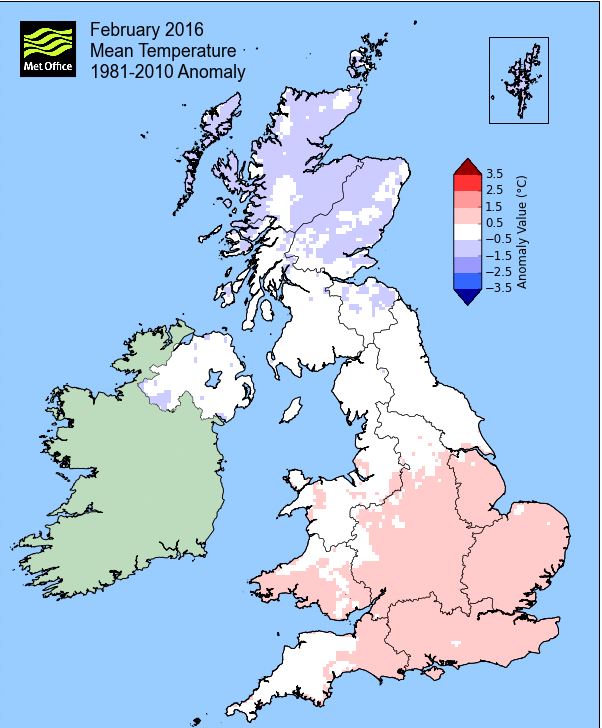
February gave us a bit of a mixed picture, having both mild and cold spells, but at last we got to see a little sun, and something more typical of winter. However, the cold end to the month only just off-set the mild start to see a slightly cooler than average month, but the dry finish to the month couldn't do the same and we finished wetter than average. Once again all three winter months have recorded over 100 mm of rain and not surprisingly, locally, this has been the wettest winter on record and by a very wide margin.
The month started unsettled with 'Storm Henry' bringing gale force winds, although little rain, with the month's heaviest rain coming during the 5-8th and then on the 16th. The first frosts came as late as the 10th and then apart from a slightly milder interlude 19th-21st, the month became gradually cooler and drier with frosts recorded every day from the 23rd. However, any snowfall was insignificant and caused no disruption.
MSLP of 1007.1 Mb was -6.8 Mb below the local average for February with no-one weather system becoming established for more than a few days at a time and whilst low pressure featured more frequently it tended to lie fairly broadly over the UK in a slack pressure gradient.
Overall a mean minimum of 0.06°c and a mean maximum of 6.51°c saw the temperature 0.3°c below the 1981-2010 average and made it the warmest February since 2014. The highest maximum temperature recorded was 10.5°c (1st), the lowest minimum -5.5°c (25th).
Rainfall of 111.3 mm (Crosby Ravensworth School 132.6 mm - Castle Scar 153.1 mm and at Reagill, 119.6 mm) made it the wettest February since 2014 (the 3rd wettest of the 9 recorded by myself) and here at Maulds Meaburn was 128.4% of average for 2008-15. Locally rainfall was typically varied quite widely, but generally below 150%, although at 224%, Seathwaite was considerably wetter than average.
At the Met' Office site at Newton Rigg, 98.6 mm (132.7%) made it the wettest February since 2014 and in a series back to 1900 this makes it the 25th wettest in that time (1 year of missing data). In a complete series back to 1954, a mean temperature of 3.35°c is the warmest since 2014 with 33 having been warmer and 29 colder in that time.
Figures from the Environment Agency’s rainfall sites were, (figure in brackets being the monthly average for 1961-90) ‘Data kindly provided by the Hydrometry and Telemetry team of the Environment Agency (Penrith)’:
Kirkby Thore 66.4 mm (48.7 mm)
Brothers Water 323.6 mm (192 mm)
Nunwick Hall 61.0 mm (51.0 mm) and
610.4 mm at Seathwaite Farm (Borrowdale - 272 mm [average for 1981-2010])
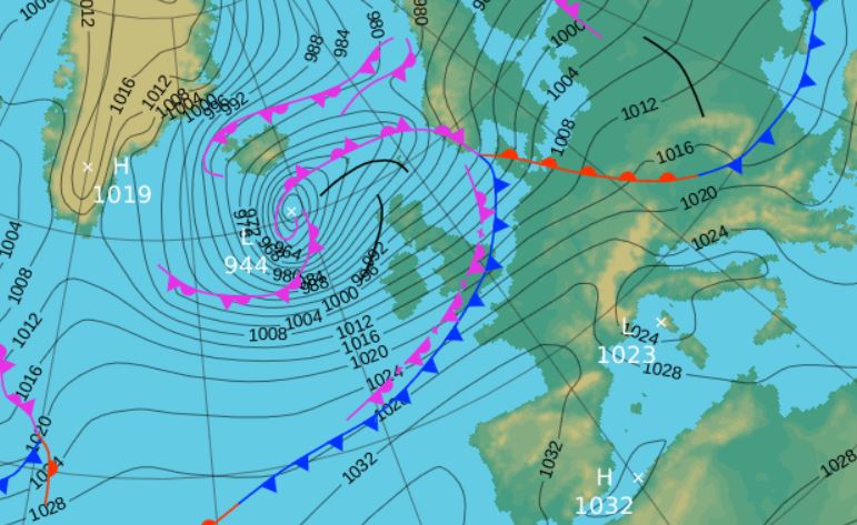
1st - 2nd The month started with storm 'Henry' bringing gale force winds that battered parts of the UK and Cumbria. Henry was a deep and significant area of low pressure (LP) that began the month west of Eire, tracking NE and then east to the north of Scotland towards Norway.
Rainfall was insignificant, but the winds were strong, the 1st seeing gales recorded both morning and afternoon and sustaining a 10 minute mean wind speed of 41 mph quite regularly and gusting to 63 mph. Those winds continued overnight into the morning of the 2nd before easing off.
3rd - 4th High Pressure (HP) to our SW then tried but never quite managed to ridge as the remnants of Henry pulled down a cool NW'ly flow. These two days had a little mix of 'bright and breezy' with the odd splash of rain, but were on the whole, fairly quiet.
5th - 9th It now became more unsettled with a regular feed of LP systems arriving from the Atlantic. A cold front brought a spell of wet (11.2 mm) and windy weather late afternoon and evening of the 5th and then the 6th saw two areas of LP west of Eire merge and bring a wet afternoon (16.4 mm).
LP then remained over or near the UK and the 7th saw more fronts arrive from off the Atlantic to bring 20.5 mm of rain. The band of rain arrived from 2100 hrs and lasted overnight, but earlier for 20 minutes, 1600-1620 hrs there had been a quite sharp hail shower.
The south of the UK and English Channel then took a turn in experiencing some rough weather as storm 'Imogen' brought gale force winds, although the centre of the low actually passed through the Midlands, the strong winds being on its southern flank. For ourselves, we saw some showers brought on the associated occlusion wrapped around the centre.
An occlusion lying east-west through the northern half of the UK slowly drifted north on the 9th after giving a little drizzle in the morning.
10th - 16th
Whilst LP remained nearby during the period, the tendency was for the pressure gradient to slacken and we had a few quieter days and even got to see some sun, which along with three consecutive dry days was enough to get excited about! HP ridged in from the Azores late in the period, bringing more widespread frosts.
The flow was typically NW'ly and subsequently it felt that bit cooler, with night-time temperatures starting to drop. The 10th saw plenty of sun, especially in the afternoon but was out done by the 11th which was sunny throughout the day as we sat in the slack pressure gradient.
There was more in the way of cloud on the 12th, with the 13th now starting to feel cool and the first day of the month that failed to attain 5°c. The next few nights would see fairly sharp frosts as the HP ridged in from the Azores, but maintained the nominal N'ly flow. The 14th saw a thin cover of snow on Crosby Ravensworth Fell and in a generally sunny day there was the odd flake of snow followed by the odd light shower in the evening and overnight into the 15th.
The 15th started with a chilly -2.7°c and the finest of snow cover and again it was a fine, if chilly day at 3.7°c (38.7°f) and then with the HP more established, the 16th was slightly colder at -3.2°c (26.2°f), but with cloud encroaching during the day and heralding the start of something more unsettled.
16th - 21st The rain arrived late in the evening of the 16th as the frontal system associated to LP south of Iceland swept east. The rain continued throughout the night into the 17th and which gave 21.1 mm credited back to the 16th to make it the month's wettest day.
Those fronts were slow to clear on the 17th, making for a damp though not particularly wet day and the 18th was an 'inbetween day' that after a cold start of -3.1°c saw plenty of sun ahead of the next LP system on the 19th.
The 19th was wet and windy in the afternoon, but these fronts cleared east quite rapidly, but then occluded and lingered over the southern half of the UK leaving us with a dull and damp day for the 20th. That occlusion or long wave front came to mark the boundary of warm and cold air and on the 21st it ventured north, maintaining the dampness, but bringing milder air with the day peaking at 9.8°c.
22nd - 29th It then turned colder with night-time frosts and a cool northerly breeze as air of Arctic origins moved south, shunting that long wave front and its milder air into the continent. HP would become a more dominant feature although LP was never far away and the occasional weak front would give the odd flutter of snow and more cloud, but finally we got to see some fine, dry, sunny days, at long last.
The best of those sunny days came at the start of the period, especially the 23rd as HP began to ridge in from the Atlantic, but the flow was NW'ly and it felt quite chilly. After clear skies and the temperature dropping to -4.6°c a trough line in the early morning of the 24th brought a spell of snow that saw the day start cold and crisp with a covering of snow.
Starting the day with a temperature of -5.5°c (22.1°f) and a grass frost of -10.1°c made the 25th the month's coldest day as the HP became slightly more dominant. This caused winds to fall light and the day itself only peaked at a month's coldest of 3.1°c despite fronts west of Eire introducing more cloud later in the day and the odd flake of snow in the evening.
The overnight frosts and fine sunny starts with cloud quickly building continued for the rest of the month as we sat within a ridge of HP, but the 29th saw that HP give way to fronts associated to LP in the Atlantic and which introduced rain late in the evening. That rain was at its heaviest overnight into the 1st, which saw 15.2 mm credited back to the 29th and thus another winter with every month notching up at least 100 mm of rain.
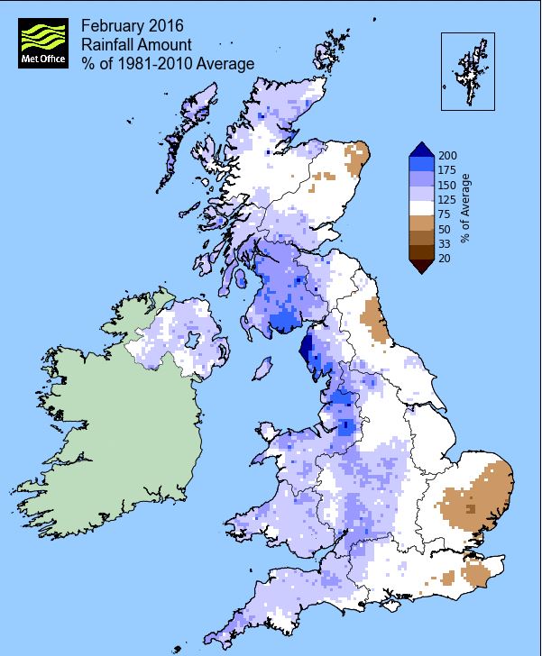
Rainfall totalled 111.3 mm for the month, with rain recorded on 19 days of which 14 were 'Wet days' (1.0mm +).
The Mean Temperature for the month was 3.28°c -- The Mean Max' was 6.51°c -- The Mean Min' 0.06°c.
We had 13 Air Frosts in the month (year 21) -- Grass frosts totalled 20 (year 38).
The 1 foot soil temp ranged from a low of 2.8°c on the 29th to a high of 5.7°c on the 2nd and 5-6th -- with a monthly mean of 4.2°c
The 1 meter soil temp ranged from a low of 5.4°c on the 21st and 29th to a high of 6.7°c on the 1st-3rd and 7th -- with a monthly mean of 6.0°c
COMPARISONS:-
* February 2016 rainfall was 128.4% of the February average for 2008 - 2015
* February 2016 was 0.18°c colder than the February average for 2009 - 2015 and 0.3°c colder than the local long term average 1981-2010
This winter has been the wettest locally on record and the best illustration of that comes from Appleby in Westmorland where rainfall records commenced in June 1856.
The previous wettest winter was 1868-69 (501.7 mm) and this was the only time that 500 mm has been surpassed, which had just pushed 2013-14 (498.5 mm) into second – 1868-69 is also the warmest winter on record in the Central England Temperature (CET) series. However, not unsurprisingly after December 2015, the winter of 2015-16 has become the wettest on record (and also the second warmest in the CET), but the final total of 609.0 mm is quite incredible in the sense that it is over 100 mm more than the previous record. I also wonder if that margin between the wettest and second wettest is in itself a record!
But one more curiosity exists – during the winter of 2013-14 there was no flooding in Appleby and I can find no mention of flooding in the winter of 1868-69 in the local papers, which just goes to show if that in 159 years of records and numerous floods in the town, the majority of which are between November and February, that an excessively wet winter doesn’t necessarily mean that flooding will result.
* winter 2014-15 was TEMP' 3.46°c -- RAIN 370.4 mm
* winter 2013-14 was TEMP' 5.06°c -- RAIN 725.9 mm
* winter 2012-13 was TEMP' 2.87°c -- RAIN 379.3 mm
* winter 2011-12 was TEMP' 3.93°c -- RAIN 308.6 mm
* winter 2010-11 was TEMP' 1.73°c -- RAIN 341.6 mm
* winter 2009-10 was TEMP' 1.20°c -- RAIN 154.0 mm
* winter 2008-09 was -- RAIN 346.8 mm
* winter 2007-08 was -- RAIN 472.4 mm
OTHER WINTER INFORMATION
-------------------------------------------------------------------------------------------------------------------------------------
                 2015-16      2014-15      2013-14      2012-13      2011-12       2010-11      2009-10       2008-09       2007-08
-------------------------------------------------------------------------------------------------------------------------------------


Air Frosts          24           32           7            48          30             40           57

Ground Frosts       50           62          34            64          59             56           81

Ice Days             0            0           0             3           0             13            6             1

Laying Snow          4           12           1            11           3             23           32            16            3

Falling Snow        15           25          13            26          19             20           39            14
JANUARY 2010
FEBRUARY 2010
MARCH 2010
APRIL 2010
MAY 2010
JUNE 2010
JULY 2010
AUGUST 2010
SEPTEMBER 2010
OCTOBER 2010
NOVEMBER 2010
DECEMBER 2010
JANUARY 2011
FEBRUARY 2011
MARCH 2011
APRIL 2011
MAY 2011
JUNE 2011
JULY 2011
AUGUST 2011
SEPTEMBER 2011
OCTOBER 2011
NOVEMBER 2011
DECEMBER 2011
JANUARY 2012
FEBRUARY 2012
MARCH 2012
APRIL 2012
MAY 2012
JUNE 2012
JULY 2012
AUGUST 2012
SEPTEMBER 2012
OCTOBER 2012
NOVEMBER 2012
DECEMBER 2012
SUMMER 2012
REVIEW OF 2012
JANUARY 2013
FEBRUARY 2013
MARCH 2013
APRIL 2013
MAY 2013
JUNE 2013
JULY 2013
AUGUST 2013
SEPTEMBER 2013
OCTOBER 2013
NOVEMBER 2013
DECEMBER 2013
REVIEW OF 2013
JANUARY 2014
FEBRUARY 2014
MARCH 2014
APRIL 2014
MAY 2014
JUNE 2014
JULY 2014
AUGUST 2014
SEPTEMBER 2014
OCTOBER 2014
NOVEMBER 2014
DECEMBER 2014
WINTER 2014
REVIEW OF 2014
JANUARY 2015
FEBRUARY 2015
MARCH 2015
APRIL 2015
MAY 2015
JUNE 2015
JULY 2015
AUGUST 2015
SEPTEMBER 2015
OCTOBER 2015
NOVEMBER 2015
DECEMBER 2015
REVIEW OF 2015
© Darren Rogers 2016
Want to comment on this site? email